Hello, is it possible to make something like this in Kodular?
http://159.65.238.235/#/page/indexes/global-peace-index/
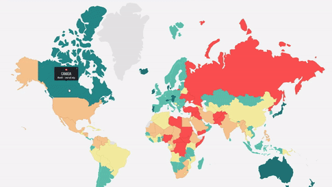
I have all the required data stored in air-table and i’m looking a way to make that map. It will be a great visualization.
Hello, is it possible to make something like this in Kodular?
http://159.65.238.235/#/page/indexes/global-peace-index/
I have all the required data stored in air-table and i’m looking a way to make that map. It will be a great visualization.
The easiest way would be to paint every country in a different color, even if it looks like some have the same color, you will need to make it different for the app (like blue r=0 g=0 b 255 and blue r=0 g=0 b=254)
Then use that color number (in Kodular format or in hex) as a key in a LOOK UP IN PAIRS list.
That way, each color touched will be the key to find out what country the user touched.
My main problem is how can i give my data to the map. The different colors are represent how big is the data.
1 = green,
2 = blue,
3 = yellow,
4 = red etc.
The map (countries) should change colors after the data inserted into it.
That’s not easy to do in Kodular canvas. You will be better of trying something in html 5 canvas with svg vector and visualize in a webviewer.
I think this is interesting for you.
This topic was automatically closed 30 days after the last reply. New replies are no longer allowed.