The App with NMEA Extension crashes when I press start. This happens in companion and also in installed test. It first shows the satellite view and then it crashes. The standard Kodular version works well on my phone, companion and installed test.
Samsung A3 2016 Android 7.01
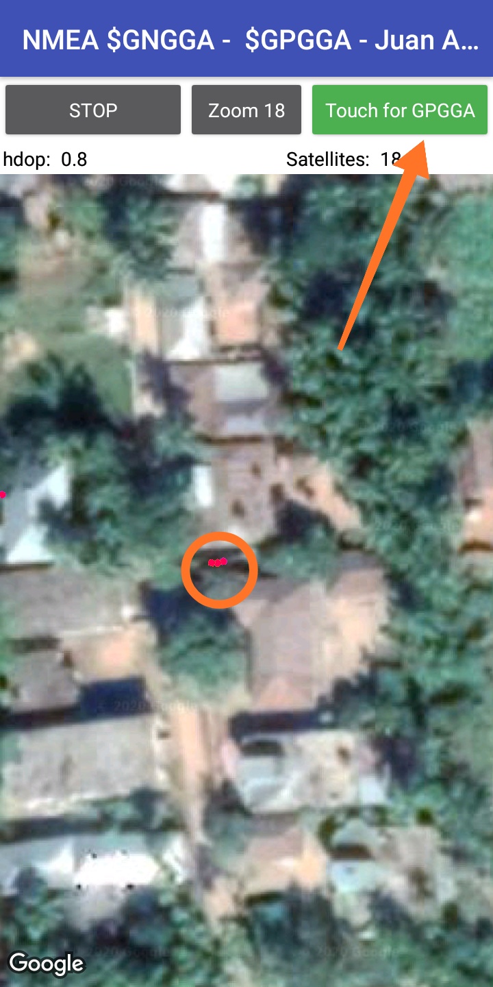
The GPS of the mobiles have an accuracy of about 3 m, each time they pick up a signal can come with different data.
The information captured by this extension is in NMEA format, within that information we can obtain data sent by different groups of satellites.
If the information begins with GP they are American satellites, GL (Glonass Russian satellites), GA (Galileo, European satellites), GN set of several satellites, for example GP + GL.
Please take you a little time and read this whole thread again. Maybe you will get the idea why your last 2 questions are completly useless.
You may also use the translation button .
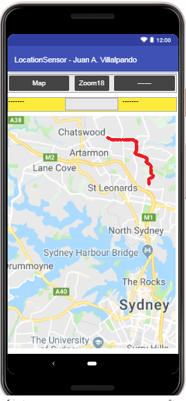
I wanted to check if you can get more accuracy in the location of the device by GPS than using the SensorLocation component of MIT App Inventor and Kodular.
I built the extension KIO4_LocationSensor.aix, which I could get:
Latitude, Longitude, Altitude, Speed (m / s), bearing, bearingTo, distanceTo, getTime and convert.
bearingTo and distanceTo refers to the Properties: LatitudeTo and LongitudeTo
adminArea, countryCode, countryName, feature, locality, phone, postalCode, premises, subAdmin, subLocality, subThoroughfare, thoroughfare, url
declination, fieldStrength, horizontalStrength, inclination, x, y, z
all in the same extension, as we can see in:
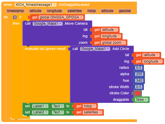
With this class we can obtain the Nmea data, the longitude and latitude data are similar to that of the LocationSensor component, but we can obtain other data such as number of satellites, hdop, geoidal, magnetic var., Course mg, therefore they are two different extensions .
I actually thought to make a pedometer plus route drawer app but, when i tested the app without pedometer it worked great but with the pedometer component the accuracy dropped to 0 it made dots anywhere. Also how can i connect the dots to make it look more continuous please help
If you can parse NMEA sentenses from the built-in GPS, could you teach me how to do it? I need to parse NMEA sentenses from an external bluetooth (GPS+GLONASS) device.
My bluetooth device is Nordic 52833, GNSS device is MT3333, NMEA sentenses are streaming on my Android app now. I don’t know how to parse NMEA to Lat/Log, for google map. Should I use Android tutorial instead of MIT app inventer? I am a hardware engineer, sorry to ask such a basic question.
hello, I tried these blocks but I find that the acquisition of the position remains much slower than when you open Google map, waze, or any other application using a gps. they have the position instantly. do you know why and what is different?